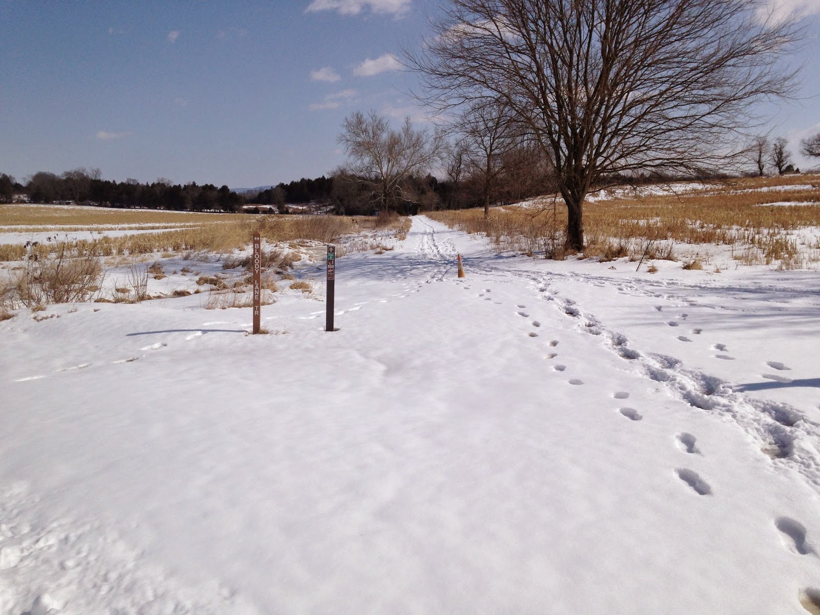
Showing posts with label Antietam. Show all posts

Thursday, March 12, 2015

A Snowy Hike on Antietam's Three Farms Trail

This past weekend I traveled through Maryland and Pennsylvania, and on Sunday morning I spent a few hours at the Antietam National Battlefield. After nasty weather over the past several weeks, Sunday turned into a beautiful, spring-like day; perfect for a hike on Sharpsburg's snow-covered fields.

The Antietam National Battlefield has established excellent hiking trails for the intrepid battlefield tourist. The park's trail system allows a visitor with enough time and stamina to explore the entire battlefield, from the North Woods to Snavely's Ford, on foot. On previous visits, I had explored many of these trails. On Sunday, with only a few hours to spare, I decided to seek out one that I'd not previously experienced.

The Three Farms Trail does not explore areas where intense combat took place during the Battle of Antietam. However, it takes hikers to some of the quietest and most beautiful locations on the battlefield.As its name implies, the path winds its way through three farms that existed during the 1862 battle. It begins at the William Roulette farm, and passes through the secluded fields and buildings of the Joseph Parks and Joshua Newcomer farms. As you make your way south along the west side of Antietam Creek, you pass over terrain traversed and occupied by elements of the 2nd and 5th corps of the Army of the Potomac during the battle on September 17th, 1862.

A view taken from near the Visitor Center on the Dunker Church Plateau looking toward the Mumma (left) and Roulette Farms (right), and beyond to the South Mountain Range. The Mumma Farm Lane runs across the middle of the view.

You cannot access the trail head readily via car. First, you must hike a portion of the Bloody Lane Trail which begins at the Visitor Center, and visits the Mumma and Roulette Farms. More than 5,000 United States soldiers commanded by Brig. Gen. William French passed over these farms on their way to attack Confederate forces in the Sunken Road on the morning of September 17th.  

The Battle of Antietam brought a great deal of suffering to the Roulette Family. Their farm endured extensive damage as a result of the thousands of soldiers that tramped over it. During the battle the farm became a field hospital, and William Roulette later claimed that some 700 soldiers were buried on his property. The family's youngest daughter, Carrie May, later died of a disease likely brought by the armies.


A second view of the Roulette Farm House and its springhouse and kitchen.
This view was taken from the ravine through which French's division emerged onto the battlefield.


After passing these farm buildings, the Bloody Lane Trail follows the Roulette's old farm lane. The start of the Three Farms Trail is found at the location where the farm lane curves to the southwest.

The Roulette Farm Lane can be seen in the foreground. In the distance, the Bloody Lane observation tower rises up above the ridge line. Cresting that ridge, United States soldiers recoiled from a withering fire delivered by Confederates resting in a sunken road on the opposite slope.
The trail head for the Three Farms Trail leads to the northeast away from the Bloody Lane.

The Three Farms Trail connects Antietam National Battlefield's northern and southern trail networks. From the Roulette Farm, it winds its way southward, part of the way along Antietam Creek, until it connects with the Sherrick Farm Trail south of the Boonsboro Pike, modern day Route 34.


This rutted road trace remains visible on the landscape today. In 1862 it connected the
Parks, Newkirk, and Kennedy Farms to the Boonsboro Pike near the Middle Bridge over Antietam Creek.
Along the way, the recreational trail joins the deep-cut trace of an old roadway as it makes its way toward the Joseph Parks farm. In 1862 this road connected the Parks Farm with the Boonsboro Pike to the south, and the Kennedy and Newkirk Farms to the north.

The Joseph Parks Farm today. Both the barn and the home in the background date to the 1830s, though both have seen alterations over time.

Eventually, the path climbs a hill and emerges into a clearing occupied by the historic buildings of the Joseph Parks Farm. According to a Cultural Landscapes Inventory completed by the National Park Service in 2011, both the main house and barn were initially constructed around 1830, though both have undergone alterations. This land was long owned by the Mumma Family, who originally built the house and farm buildings. In 1861, the Mummas sold the farm to Phillip Pry. Pry owned another farm on the opposite side of Antietam Creek, which became Maj. Gen. George McClellan's headquarters during the battle. Pry operated this property as a tenant farm, and historians believe that the tenant at the time of the battle was Joseph Parks. On September 16th, United States Soldiers crossed the creek near the farm to protect the middle bridge. The following day, Union infantry and cavalry traversed the property, artillery batteries established positions on the farm to fire against Confederate positions on Cemetery Hill, and its likely that the homestead became a field hospital. Just five days after the Battle of Antietam--photographer James F. Gibson captured a view of the Parks farmstead in a view entitled "Antietam, Md. Another view of Antietam Bridge."
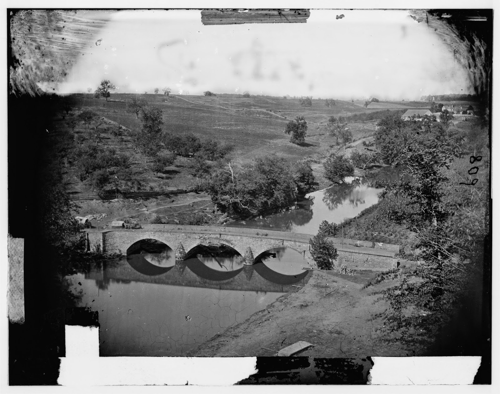
Gibson photographed the Parks Farm from heights on the eastern side of Antietam Creek,
overlooking the Middle Bridge.
A zoomed-in view of the previous photograph, focusing on the Joseph Parks Farm.
The house and the barn still stand today.

Moving on from the Parks Farmstead, I neared the Boonsboro Pike. Here the trail continues on past the Newcomer Farm, crossing the pike to eventually link with the Sherrick Farm Trail. Instead of completing the trail, I chose to turn aside here onto the Tidball Trail, which ascends a steep ridge line to the position of Captain John C. Tidball's Battery A, 2nd United States Artillery during the battle.


After crossing the Middle Bridge before noon on September 17th, Tidball's men hauled their six rifled cannon by hand up this steep ridge, where they expended some 1,200 rounds of ammunition protecting federal troops positioned near the Bloody Lane and supporting Burnside's advance to the edge of Sharpsburg that afternoon.

The views obtained from Tidball's position, I think, are some of the best you will find on the Antietam Battlefield. From this one position you get a good view of the terrain over which the 2nd Corps assaulted the Sunken Road, the ground over which Burnsides' 9th Corps advanced in late afternoon against the Confederate right, and an imposing view of the rolling, open terrain that McClellan's soldiers would have had to cross to attack the Confederate Center on the outskirts of Sharpsburg. Many--including myself--have criticized George McClellan for not crossing his reserves over the Middle Bridge on September 17th to attack Lee's center when one more push could have potentially crushed Lee's army. Viewing the terrain from this vantage point, however, I saw the tremendous obstacles to such a movement.

The Antietam Battlefield is surprisingly compact, but the rolling nature of the terrain rarely allows you such a sweeping view of the battlefield. Here are a few of the shots that I snapped in this location:

From the ridge line looking back toward the Parks Farm.
Another view of the Parks Farm. I took this picture as I ascended the ridge line toward Tidball's position.
A view from Tidball's position toward the surprisingly close Bloody Lane Observation
Tower, just four-tenths of a mile away.
A view looking southwest across the Boonsboro Pike toward Antietam National Cemetery
(marked by the evergreen trees on the hill in the right background).
A close-up view of Cemetery Hill - with the National Cemetery to the left of the road.
Lee's center rested on that ridge line on September 17th, 1862.
A zoomed-in view looking southwest toward where the final advance of Burnsides' corps was turned back by Confederate reinforcements. The distant hill in the left background marked the farthest advance of the 9th Corps.

Running short on time. I did not complete the Three Farms Trail after viewing Tidball's position. Instead, I struck out across country to the Bloody Lane, and completed my hiking circuit back to my car at the Visitor Center. After a brisk two-hour hike, I started back on my way home to Virginia. If you have the time, hiking is the only way to truly understand a battlefield like Antietam, and the Park Service has done a great job creating these trails that provide access to the under-visited locations on the field. The different views and terrain features you will observe while hiking will likely change your perspective of the battle.

Wednesday, August 7, 2013

A Hike at Antietam

For those of you who don't know, I am getting married in one month. This past weekend my best man arranged a "bachelor party" of sorts, though certainly not a typical one. The full schedule included camping near Hagerstown, Maryland, hiking on the Antietam Battlefield, and a trip to a minor league baseball game. It was perfect.

I last visited Antietam in the spring of 2008. The battlefield is in a wonderful state of preservation, and it provides several contrasts to Gettysburg. You won't find the same the commercial development in the town of Sharpsburg that you see at Gettysburg, and the veterans left far fewer monuments on the field. Antietam is smaller battlefield too, and I love the various hiking trails that the National Park Service has developed. There are many places for you to get off the beaten path at Gettysburg - The trail to Willoughby Run, the path at the Slyder Farm, the Weikert farm lane, Pickett's Charge, and the old trolly line are some of my favorites - but I am not aware of anything that approaches the comprehensive trail system, complete with self-guided walking tours, that exists at Antietam.

Not a sight you see every day. As we hiked past the Dunker Church,
we ran into the mascot of the Hagerstown Suns, cheering
on runners at the nearby finish line. Photo by Ryan Stauffer.
We arrived at the Visitor Center at 9 a.m. on Saturday. While my best man handled other arrangements for this weekend, our battlefield itinerary was left to my discretion. We had six in our group, and all but one of us had toured the field before. The forecast threatened rain, but we were determined to tour the field on foot - in my opinion the only way to get a grasp of the terrain features of a battlefield. We browsed the exhibits briefly, and spent some time orienting ourselves outside on the high ground around the Visitor Center. We then drove up and parked a car at the North Woods tour stop, dodging the rear elements of a 5K taking place on the battlefield that morning. Once we arrived at the North Woods, we began our first hike - the Bloody Cornfield.

I had come prepared with a few resources to help our understanding. In advance I had printed out all of the hiking trail guides offered on the NPS website. Each of the trails have multiple interpretive stops, marked by posts. The trail guides provide very brief descriptions of the action at each stop. In addition to this, I had downloaded the Civil War Trust's Antietam Battlefield App. The Trust has developed several of these apps, all of them very impressive. They provide multiple guided walking and driving tours of each battlefield, complete with interpretive text and videos. They are also GPS enabled, so that you can locate yourself on a map. Finally, the apps feature augmented reality "field glasses" that you can use to scan the field through your camera lens and view labeled landmarks and terrain features. The Antietam app's tours did not always match up with the hiking trails, but frequently there was a great deal of cross-over. In addition to these resources, I also packed William Frassanito's study of Antietam photography, and a mini-tour booklet put together by Antietam historian John Michael Priest.

The monument to the 15th Massachusetts
We followed the hiking trail south to Miller's Cornfield, and considered the back-and-forth fight that ruptured the chilly early-morning air on September 17th, 1862. Then, we picked up the West Woods hiking trail that begins by the Dunker Church. This is a trail I've never explored before. It takes you to the Philadelphia Brigade monument, and then loops around into the West Woods, allowing you to explore the terrain crossed by Maj. Gen. John Sedgwick's 5,000 man division. The path emerges into the open at the western end of the woods near the 15th Massachusetts monument - the unit that suffered the most casualties in the battle - and then it reenters the West Woods and winds down to the monuments to the 34th New York and 125th Pennsylvania (a 12th Corps unit). These two regiments held the left flank of Union forces in the West Woods when they were struck by a devastating Confederate counterattack that would eventually rout Sedgwick's entire command. Walking through this terrain, I observed many hallows and ravines in the woods, and came to understand how confusing a place this must have been for Sedgwick's men. The division was stacked up in a column of brigades when it was struck on its flank and rear, and the smoke of battle that filling the wooded ravines must have made it very difficult for officers and men to understand what had happened.

After a brief lunch at the Red Byrd - a restaurant on the Boonsboro Pike that  I would highly recommend - we returned to the Visitor Center and headed out on the Bloody Lane hiking trail. This pathway had overgrown a bit, suggesting that it sees seldom use - but it is an excellent way to understand the fight for the Bloody Lane from the perspective of the troops in the federal divisions of William H. French and Israel Richardson. The trail leads out from the Visitor Center to the the Mumma and Roulette Farms. The trail guide provides information on these two families and the fate they suffered during and after the battle. The pathway then curls around the Roulette Farm, and picks up the line of march for French's division as it crested a rise sixty yards in front of the Sunken Road. It was on this rise that French's men first met with withering volleys of musketry from the Rebel forces firing behind fence rails in the lane. For two and a half hours, the Confederate forces in the lane held the 2nd Corps at bay and protected the main approach to Sharpsburg. Meanwhile, just across the Middle Bridge McClellan refused to commit his reserves to the engagement. The Confederate position finally collapsed at about 1 p.m., but Richardson and French's divisions could push on no further.

A view of the Bloody Lane. This photo was taken in 2004. Unfortunately the weather on my recent trip was not so nice.

After a brief jaunt up the Bloody Lane observation tower, we returned to our vehicles at the Visitor Center, and drove down to Burnside Bridge. By now, light rain had set in. We visited the bridge and then considered the weather before we headed out on the Final Attack trail. We decided to give it a go. Unfortunately the rain increased as we got out on the trail, and at some points it became a steady downpour. We were mostly prepared with rain gear though, and we pressed on.

The Final Attack trail is one of my favorite Civil War hikes. This 1.7 mile loop covers Burnside's final attack toward Sharpsburg on the afternoon of September 17th, and A.P. Hill's successful counterattack. The hike takes you across the farm owned by John Otto during the battle. This farm remained in private hands until the Park acquired it in 2003. Today, it is easy for battlefield tourists to overlook the significance of fighting on this farm. The dramatic storming of the bridge across the Antietam attracts more interest. If you do make it out on the trail, you can visit several monuments that you cannot access from any tour road. You will also reach some of the best vantage points for obtaining panoramic views of the Antietam landscape.

Many battlefield tourists end their trip on the southern end of the battlefield here at the Burnside Bridge. But the
Park Service has developed a great hiking trail that follows the 9th Corps's advance well beyond the bridge
to the very edge of Sharpsburg.

The pathway heads west from the Burnside Bridge parking lot, and connects to the Otto Farm lane. The terrain the 9th Corps faced as it drove toward Sharpsburg was daunting. The undulating landscape gradually rises from the valley cut by the Antietam to the highest point held by D.R. Jones' Confederate division near Sharpsburg. Once the Otto farm lane is reached, the trail turns south and loops down beyond the 9th Corps flank to the southern boundary of the Antietam Battlefield, and the site where A.P. Hill's soldiers arrived that evening. Here you stand in what is known as the 40-acre cornfield, and you overlook a gully. Rookie soldiers of the 16th Connecticut and 4th Rhode Island were driven into this gully by Hill's advancing men. The landscape here reveals what a terrible ordeal these soldiers must have suffered through.

The Final Assault trail ended our hike at Antietam. We didn't have time to check out several other trails on the battlefield. A devoted hiker can actually explore the entire field on foot while rarely running into the auto tour routes. Most of the trails link up together rather easily, and the park's Three Farms trail actually connects its northern trail network (the Bloody Cornfield trail, the West Woods trail, and the Bloody Lane trail), with its southern network (the Sherrick Farm trail, the Union Advance trail, the  Snavely Ford trail, and the Final Attack trail).  Sometime I would love to do this. Judging from maps, it is about an 8 or 9 mile hike.

If you want to check out some of these trails, visit Antietam NPS's guide to hiking the battlefield to download their tour maps. For a few of these trails, you can also download a more in-depth podcast tour delivered by Antietam Park Rangers from the Civil War Traveler website.  Finally, I would also highly recommend that smart phone users check out the Civil War Trust's Antietam App as an additional resource.

What are some of your favorite Civil War hiking trails?

Thursday, May 9, 2013

Library Corner: To Antietam Creek

To Antietam Creek
By Scott Hartwig
Johns Hopkins University Press, 2012

To many scholars, the Battle of Antietam represents one of the crucial turning points of the Civil War. In addition to earning a sad distinction as the bloodiest day in American history, the battle's connections with Lincoln's Emancipation Proclamation highlight it as a dividing line between a war for the Union as it was, and a war to redefine freedom. And yet, far fewer book-length studies exist for the Maryland Campaign than for Lee's second invasion of the North. Standard works include Stephen Sear's Landscape Turned Red (1983) and Joseph Harsh's Taken at the Flood (1998). John Michael Priest's Antietam: The Soldiers' Battle (1994) attempts to tell the story from the perspective of the common soldiers on the ground, and many other works explore different aspects and personalities of the battle and the campaign. More recently, Richard Slotkin's The Long Road to Antietam (2012) sought to interweave the Maryland Campaign with the story of the political battle between McClellan and the Lincoln Administration over the direction of the war effort.

With this first of two volumes, Scott Hartwig has contributed a book which will surely join the pantheon of the best works on the Maryland Campaign. 650-page books rarely fit into the "can't put it down" category, but this one did. To Antietam Creek features stunningly detailed accounts built through an extensive mining of primary source manuscript collections and what must have been long hours of traversing the landscape at several battle sites to understand terrain. Sometimes books that are so rich in detail collapse under the weight of their own thoroughness. However, Hartwig's writing skills also shine here, and his narrative captivates the reader, bringing the drama of the campaign to life.

In this first volume, Hartwig sets out to raise the profile of the Maryland Campaign's other major actions. While the Battle of Antietam saw tremendous bloodshed and brought about war-altering results, it also overshadowed the engagements and actions of Union and Confederate forces at Harpers Ferry and South Mountain. The events of the Maryland Campaign leading up to the Battle of Antietam had significant consequences, and Hartwig believes that many accounts of the Campaign overlook or ignore their import. He begins his narrative in the aftermath of the Union disaster at Second Manassas, and details George McClellan's fall from the Lincoln administration's graces that summer, and his sudden return to power in the crisis of September of 1862.

After setting the scene with a review of the strategic picture militarily and politically, Hartwig introduces his readers to both armies. He provides a extensive analysis of strengths and weaknesses, comparing each army's leadership down to brigade level, staff capabilities, and the organizational structure of infantry, artillery, and cavalry. Here Hartwig challenges popular misconceptions. First - he argues that the numerical superiority of the Army of the Potomac, especially at the outset of the Maryland Campaign, has been greatly overstated. Citing the continued grip of the Lost Cause over the historiography of the campaign, Hartwig quotes a Union soldier who complains: "A few more years, a few more books, and it will appear that Lee and Longstreet, a one-armed orderly, and a casual with a shotgun fought all the battles of the rebellion, and killed all the Union soldiers except those who ran away." Second, Hartwig gives a bit of respect to the performance of Union cavalry during the Maryland Campaign. While traditional narratives describe the Army of the Potomac's horse soldiers as coming of age in the Battle of Brandy Station and after, Hartwig gives credit to Colonel John F. Farnsworth's brigade, and notes that during this campaign it performed well when used appropriately.

A review of both armies complete, the rest of the book provides an in-depth narrative as the Maryland Campaign unfolds, including a ground-level view of the battles for Turner's Gap, Fox's Gap, and Crampton's Gap, as well as Stonewall Jackson's operations against Harpers Ferry. The author demonstrates a keen understanding of the impact of terrain on the outcome of engagements. He also excels when assessing the leadership qualities of commanders at the operational level, examining the contributions of regimental commanders as well as army commanders. At South Mountain, Hartwig provides a mostly positive review of performances within the Army of the Potomac, and a negative (if sympathetic) analysis of D.H. Hill's performance in command of Confederate forces. At Harpers Ferry, readers come to understand the excellent cooperation and daring of Confederate forces, and the utter ineptitude of Dixon Miles commanding the Harpers Ferry garrison. The Union capitulation here, Hartwig points out, is the largest surrender of Union troops in the war, and the largest surrender of United States forces up until World War Two. The author argues that Stonewall Jackson's success here should rank as one of his greatest achievements, given its difficulty and the magnitude of the results. He believes the outcome at Harpers Ferry has lost its "glow" because Antietam followed so quickly on its heels. Had the Confederate army withdrawn after the success here, and not fought at Antietam, the campaign may have been viewed as a Confederate success. Hartwig reserves especial praise for Lafeyette McLaws and his handling of a delicate situation in Pleasant Valley. He reserves great scorn for the commander of the Army of the Potomac's Sixth Corps, William Franklin. Franklin's delays on September 15th squandered a brilliant opportunity his own soldiers earned by storming Crampton's Gap the evening before.

To close the book, Hartwig brings both armies to the banks of Antietam Creek, reviews in detail the comparative strength and deployment of troops on September 15th and 16th, and covers the opening clashes in the East Woods that night. In assessing Lee and McClellan, the author gives mixed reviews. He credits McClellan with commendable efficiency in storming the gaps of South Mountain, and dishes out partial blame for his failure to lift the siege of Harpers Ferry to his subordinate, William Franklin. Hartwig also rejects the idea that the Army of the Potomac could have attacked Lee on the afternoon of September 15th, stating in a footnote: "Writers who have proposed the idea that McClellan could have attacked Lee on the 15th have no concept of the time needed to march an army of 70,000 men approximately twelve miles, reconnoiter the enemy's position, issue orders, and deploy for battle." However, Hartwig does take McClellan to task for wasting precious time on September 16th, and for his clumsy preparations to assault Lee's positions that afternoon and evening. He also questions whether McClellan was wise to break up his army's wing structure on the eve of battle without good reason.

Turning to Lee, Hartwig credits the Virginian's audacity and his desire to maintain the initiative throughout the campaign. He also notes the remarkable (if not always perfect) working relationship that Lee maintained with his two principle subordinates, Longstreet and Jackson. However, Hartwig believes that Lee asked too much of his army in this campaign, and that the straggling that resulted could have led to disaster. He also questions Lee's understanding of the condition of his army, and notes that Lee's stand along the banks of Antietam Creek was a useless and unwise risk.

Throughout the book, the reader comes to understand that the Maryland Campaign represented a turning point in the war in more ways than one. The first phase of the war, Hartwig argues, ended on the night of September 16th. After that night, the possibility of a negotiated settlement, with slavery in tact, died. He also argues that the Battle of Antietam marked the end of the idealism of the war for the soldiers who fought there. This is best summed up in a great passage on page 514:
As McClellan and his large staff swept down the turnpike, the soldiers who filled the sides of the road leaped to their feet and cheered him wildly. "Such a magnificent reception was worth living for," wrote Palfrey. On September 15, 1862, the Army of the Potomac still retained some of the innocence and enthusiastic ideals of 1861, and South Mountain upheld the boundless confidence they placed in McClellan. That September afternoon's victory still danced gloriously in the air, the end seemed in sight, and the man who, in their eyes, had delivered this all was riding to the front, waving his hat and brimming with confidence. But they would never cheer him again with the feeling they did that day. What would come in the next three days would forever dim their starry-eyed idealism. Most of them would still love McClellan and cheer him when he passed, but the army would mature on the banks of Antietam Creek; they would come to understand that the road ahead would be hard and bloody, and that their beloved general might not be the man they would follow to ultimate victory.
If you haven't read this book, and you are interested in the Maryland Campaign, it's a must read. I look forward to volume two, I think it will be worth the wait.

Wednesday, April 17, 2013

The Gettysburg Homefront During the Maryland Campaign

Newspapers are one of my favorite primary sources to delve into. When you spend time with historical newspapers from a community, you get a good feel for that community. You begin to understand the major issues that concerned its citizens, and the principal actors that held down leading roles. You also begin to understand the divisions that existed. In my readings of Gettysburg's newspapers, I've become more interested in learning about this community over the entire course of the Civil War. We tend to focus on Gettysburg's citizens only when discussing civilian experiences during the battle itself, or how those civilians coped with the aftermath of the battle. Yet the war did not first arrive on Gettysburg's doorstep on July 1st, 1863. The crossroads town sat just eight miles from the Mason Dixon Line, and not far from the Potomac River. Gettysburgians worried about the potential of enemy raids and invasions from the early days of the war, and not without cause. And when Robert E. Lee's army invaded Maryland in September of 1862, Gettysburg prepared for the worst. A review of Gettysburg's newspapers from that September provides us with a first-hand look at how its civilians experienced, and reacted to, their first brush with an invading enemy.

Lee's army began crossing the Potomac River on September 4th. That same afternoon, Pennsylvania Governor Andrew Curtin issued a proclamation, recommending that companies of militia form to defend the state from invasion. Rumors swirled through Gettysburg over the next few days. But the true excitement and panic began on Saturday, September 6th.

On Monday, the Compiler carried the story:
There was no little excitement here on Saturday morning last. Several persons arrived from Frederick, Md., stating that 30,000 rebels had crossed the Potomac at Noland's Ferry, and were on the march for Frederick.... At 5 o'clock about 300 sick soldiers arrived here from Frederick, and were well cared for by our citizens until Sunday morning, when they were sent to York in a special train.

LATEST!
There was probably more bustle in this town yesterday than on any previous Sabbath during its existence. Refugees from Frederick city and county arrived by fives and tens, aggregating several hundred.--Rumor with her hundred tongues, was also busy, but few of the statements seemed to have a reliable basis.
On the same Saturday that refugees began to arrive, a large town meeting convened at the courthouse on Baltimore Street for the purpose of recruiting militia companies in accordance with Curtin's proclamation. On Monday, a total of four units began to organize. The Gettysburg Zouaves - first formed during the secession crisis in 1861 - reformed its ranks. Two additional infantry companies were commanded by Dr. E.G. Fahnestock and S.S. McCreary, while Perry J. Tate headed up a cavalry organization. Meanwhile, reports filtered into town, some credible, others not. On Tuesday, September 9th the Sentinel reported that 30-50,000 Confederates held Frederick. On the 11th word arrived that a small force of Rebel cavalry had captured Westminster.

Meanwhile, Lee's army left Frederick on September 10th to execute his instructions outlined in Special Order 191. The Army of Northern Virginia split up, part to encircle the Federal garrison at Harpers Ferry, and part to hold the passes of South Mountain west of Frederick. The Army of the Potomac pursued, and entered Frederick on the 12th. On September 13th, some Gettysburgians heard cannonading in the distance, while a few rebel deserters arrived in town with wild claims as to the strength of Lee's army. The next afternoon, Sunday the 14th, two cavalry regiments rode into town from the south, the 1st New York and 8th Pennsylvania. These two regiments would remain through the following afternoon. Throughout the day on the 14th, the citizens could hear the sounds of battle in the distance as the Army of the Potomac struggled to seize the passes of South Mountain. As they listened to the distant thunder, more than forty miles to the south many of the town's young men serving in Company K, 1st Pennsylvania Reserves fought against Alabamians for possession of Turner's Gap. In the fight that afternoon, 1st Lieutenant John D. Sadler was killed while commanding the company. According to the Sentinel, Lieutenant Henry Minnigh - himself wounded - arrived in town the following day accompanying Sadler's lifeless body. The brutal reality of war had arrived in Gettysburg, not for the first time, and certainly not for the last.

Lee's invasion took place against the backdrop of the upcoming fall elections in the North. As events moved toward a climax at the Battle of Antietam, Gettysburg's citizens debated the progress of the war, and the political fallout of the invasion. The newspapers reported the day-to-day progress of the armies alongside their own political arguments for and against sustaining the current administration's prosecution of the war. Even as President Lincoln became firmly set in his desire to issue the Emancipation Proclamation as soon as a victory came to hand, The Compiler and the Sentinel made clear that the issue of slavery remained a prominent and divisive issue in Gettysburg. The Republican rallying cry during the fall was Unionism and patriotism - everyone needed to support the war effort. Meanwhile, the Democrats decried the lack of military progress, sought to tie Republicans to the Abolitionist cause, and argued that a war for Union could be won, while a war for abolition could not. During the height of invasion hysteria in Gettysburg, the Compiler published the following argument from "a Republican" supporting the Democratic ticket:
Now, my friends, we have but one course to pursue as true Americans. I appeal to you to at once search after the causes of our troubles, and hunt up the impediments in the way of an early peace, and I hope that you will readily see them, and by the nearest road, go and crush the serpent's head. Abolitionism and Secessionism are twin sisters, and the only two questions which claim our attention; and they are so completely interwoven amongst the draw-backs to American liberty, that nothing but the waging of a simultaneous war for the destruction of both will ever restore peace, power, and prosperity in this country. Here are before our eyes two monsters to deal with--Secessionism and Abolitionism--operating conjointly and pushed forward by monomaniacs on both sides with stubborn tenacity that knows no bounds for the overthrow of these States; the former with arms in hand, openly proclaiming their purpose, and the latter lying coiled around the portals of the nation, inflicting poisonous wounds upon its body. The Government will be able to suppress the one, if the people take hold of the other. Secessionism must fall before our powerful armies, and Abolitionism is an easy prey to the united voice of the impartial peoples.
The next day's Sentinel responded:
THE TRUTH
Men who will at this day, when our nation is in a desperate struggle with traitors, seek to divide our people by a ridiculous expression of apprehension about abolitionists, can be considered in no other light than as the allies of treason and the enemies of our government. He who now seeks to distract and antagonize our people is as black a traitor as Jeff Davis himself, let him live in Seccessia or in our midst. The secessionists are now the great and only enemies who require our immediate attention, and until they are put down all other issues should be dropped.
After the Battle of Antietam, President Lincoln issued the Emancipation Proclamation. There were political consequences. In the November elections Democrats made major gains across Pennsylvania. In the 16th District, Democrat Alexander Hamilton Coffroth narrowly unseated Gettysburg's Republican representative Edward McPherson. And yet with his pen Lincoln had ended the question of a limited war for Union. By the time the armies arrived in Gettysburg on July 1st, 1863, the war for Union and the war to end slavery went hand-in-hand.

Friday, November 30, 2012

Video: 2011 Antietam Memorial Illumination

To follow up my last post - I found this video today on Antietam National Battlefield's Facebook page. Enjoy.


Thursday, November 29, 2012

A Must Visit: Antietam Memorial Illumination

Photo by Phil Romans. Creative Commons Licensing.
This time of year I often get nostalgic for my college days, though perhaps not for the normal college-nostalgia reasons. For four great years, I got to live in Gettysburg, Pennsylvania. This allowed untold hours exploring the Gettysburg battlefield, and the opportunity to forge great friendships with folks with a similar interest. My location also provided ready access to other Civil War battlefields, especially Antietam. During my four years I visited Sharpsburg more times that I can count now, though my favorite time to visit the site of America's bloodiest day was always the first weekend of December each year.

Photo by Phil Romans. Creative Commons Licensing.
In general, I love December. The five weeks or so that kick off with Thanksgiving and end with New Years might just be my favorite time of year. I love admiring my Christmas tree each night, or viewing other houses all decked for the holidays as I drive or walk about town. Back in college though, the first weekend in December meant holiday lights of a much more somber and moving nature: the Antietam Memorial Illumination.

Before arriving at Gettysburg - I had never heard of this amazing tradition. Each year on the first Saturday of December, Antietam National Battlefield honors the casualties of the battle with an incredibly moving light show: volunteers light up the fields outside of Sharpsburg with 23,000 luminaries, one for each soldier killed, wounded, or missing during the battle.

I still remember clearly my first Illumination experience in 2001, traveling with Gettysburg College's Civil War Club - which made the trek with two college vans each year. As we approached the battlefield along the Boonsboro Pike (Route 34), I discovered the popularity of this event. We pulled the vans off to the side of the road several miles short of the primary event entrance--Richardson Avenue--and joined the long line. Typically the wait to enter the Park stretches up to two hours. If you go - make sure you bring along some food and drink, and something to entertain yourself as you wait.

We made it to the front of the line and turned on to Richardson Avenue eventually. Here signs directed  drivers to use only parking lights, and our driver began to play Ashokan Farewell (a bit of mood music I suppose). At first, the luminaries simply lined the road in pairs, but as our van took one of the first corners a vast field filled with lights came into view. You might imagine what 23,000 lights looks like in your mind, but until you see it there is no way to describe it adequately. I remember too that in addition to the amazement of seeing the vast fields lit up, I also came away astonished by the distance covered by these lights: the tour stretches nearly 5 miles in length.

Photo by Eric Gilliland. Creative Commons Licensing.

I was hooked after my first experience, and returned twice more during my college years. I missed one year due to an early season snowstorm. In my opinion, the Memorial Illumination is an incredibly unqiue way to take a moment during the busy holiday season to honor those who fell long ago, and to contemplate the human toll of war. It's also heartening--given the numbers that turn out each year--to see how many people agree with me.

Since college I have not had the opportunity to attend an Illumination. I hope one day to make it back. But until I do, each year at this time I take a moment to think about my experiences attending the Illumination, and to remember those who gave the last full measure of devotion.

Thursday, September 20, 2012