After an unusually harsh winter by Virginia standards (or so I am told), the weather has started to turn the corner. With Saturday's forecast calling for sunny skies and temperatures in the mid sixties, I decided a day on a battlefield was in order, and headed out for the Wilderness.
I love my drive to this battlefield from Charlottesville. It carries me through Orange along Route 20, which traverses one of the roads that Lee's army took from its winter camps around Orange to confront the Army of the Potomac in the brambles of the Wilderness in early May, 1864. Route 20 also passes through the contested ground of Meade's aborted Mine Run campaign of November/December 1863.
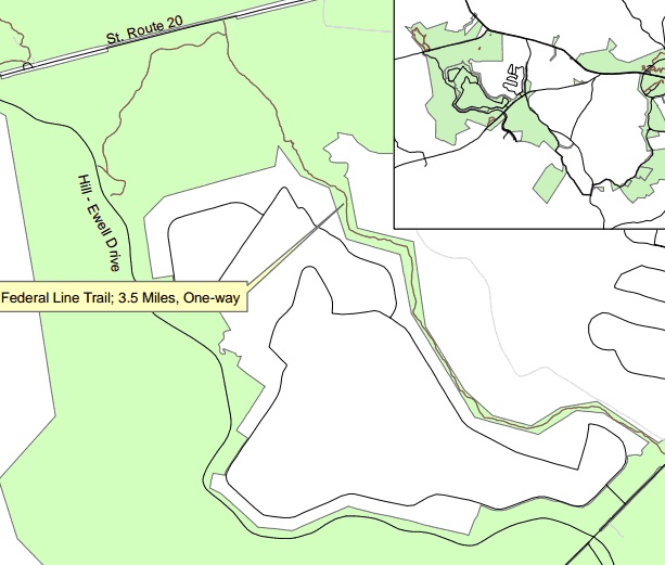
The Wilderness Battlefield features several hiking trails. I decided to start my day by exploring one I've never hiked, the Federal Line Trail, with Gordon Rhea's
The Battle of the Wilderness in hand. This 3.6 mile (one way) trail winds along the remnants of the Army of the Potomac's earthworks that stretch between the Orange Turnpike (modern Route 20) and the Orange Plank Road. The trail head is located on Hill - Ewell Drive at a picnic area between stops 3 and 4 of the driving tour.
 |
| Confederate earthworks along the start of the start of the trail. |
It begins along the main Confederate line of battle and follows a northeasterly direction toward the Orange Turnpike. Through these woods on the afternoon of May 5th the men of Gouvernour K. Warren's Union 5th Corps rolled forward on their way to assault Richard Ewell's men south
of the Turnpike, and were repulsed.
 |
| Snow-covered earthworks of the Union 5th Corps. |
Once the trail nears the turnpike, it turns sharply south and begins to wind along the remnants of entrenchments built by 5th Corps. The veterans built these works along a ridge line west of the Lacy Plantation clearing, where Warren had set up his headquarters. The earthen fortifications are in a pretty decent state of preservation, and white snow still clung to the mounds in places where the sun struggled the penetrate the Wilderness's canopy.
 |
| If you look closely you can see the half-moon shape of a lunette fortification here, built to protect an artillery piece supporting Warren's battle line. |
Among the remains of the battle here are twelve lunettes dug to protect artillery pieces. Though the pieces were positioned along a fairly prominent ridge line, the dense foliage likely prevented the guns from having any significant effect in the battle.
 |
| The descent into the Wilderness Run Valley. |
Eventually, the trail descends rapidly into a beautiful ravine cut by Mill Branch, or North Wilderness Run. The trail crosses over the small stream on a recently built foot bridge, ascends a slight ridge, and then descends again into a ravine through which Wilderness Run cuts through. This area seemed to me one of the battlefield's hidden gem locations in terms of obscurity and beauty, and it also gave me a new appreciation for the difficulties faced by the Federal troops during the battle.
 |
| Mill Branch. |
On the morning of May 5th, the lead elements of Warren's 5th corps broke their camps around Wilderness Tavern. They left the Turnpike near the Lacy Plantation and blindly groped through this area, slogging along a narrow wagon path that cut through the ravines and lowlands toward Parker's Store, several miles to the southwest. Eventually, Warren's lead division emerged from the thickets on the high ground of the Chewning Farm, a clearing that if held, would have prevented the Confederate army's two wings from linking up. With arrival along the Turnpike of Confederate troops, this division later abandoned the strategically important position to link up with the rest of the 5th Corps attacking to the north. On May 6th, the men of the Union 9th Corps also plunged through the ravines of Wilderness Run in a vain effort to exploit the gap that existed between the two Confederate wings.
 |
| Modern footbridge over Wilderness Run, supported by stone abutments from an older structure. |
 |
| Wilderness Run. |
South of Wilderness Run, the Federal Line Trail narrows, along with the NPS Boundary lines. The path continues to follow Union earthworks, but the works run essentially through the backyards of housing developments.
 |
| Here the park land runs close up to housing development. |
I considered pressing forward to complete the entirety of the trail, which round-trip would have been a hike of over seven miles, but I instead chose to return to my car and explore a few other areas of the battlefield.
I made two quick stops at Auto Tour stops 4 & 5, the Higgerson and Chewning Farms, both of which have fairly short paths that get you out of your car. Standing in the clearing on the Chewning Farm, you begin to contemplate the possibilities that may have existed had the 5th Corps maintained its hold on this vital position on May 5th. The commander of the division that took control of this farm was General Samuel W. Crawford. Assisted by Warren's aide Washington Roebling, Crawford argued unsuccessfully against orders to abandon the cleared heights. A more concerted effort to reinforce Crawford and hold the Chewning Farm perhaps could have permanently split the two wings of Lee's army, allowing the Army of the Potomac to deal with each in turn. It is up to debate however, whether such an opportunity truly existed.
 |
| Looking north from the Chewning Farm clearing toward the Turnpike. |
After a brief lunch, I returned to the battlefield to explore a more commonly visited locale, Saunders Field. Rhea's book in hand I followed the path of the 5th Corps's noon-time assault across this field that met such a slaughter, and then moved on to take in the view from the Confederate lines opposite.
 |
| Looking back across Saunders Field from the Confederate perspective. The small white monument in the center-left distance is a memorial honoring the 140th New York. |
All in all, I had a pleasant spring day on the battlefield. The Federal Line Trail is definitely something to check out if you want to explore an area of the Wilderness not often seen by general visitors. A word of caution however - the trail does not currently feature interpretive signage, and no NPS walking tour brochure exists as of yet. If you plan to try out this trail, you will need to bring your own maps and resources. Rhea's book is a great option.

My ancestor (grandfather) was killed somewhere along this trail, I believe somewhere near where Parker store road crosses wilderness run. He was in Ramseur's Brigade 4th NC, they came in to halt Burnside's advance to cut thru the line. I would love to go there one day to see for myself. Thanks for the write up and pictures.
ReplyDelete